
Digital Compass Altimeter 8 in 1
3.4Editor score
Eight functions in one
Affordable price point
Backlight for night use
Finding the right handheld altimeter is crucial for outdoor enthusiasts who need precise elevation data. Whether you are hiking, camping, or climbing, a reliable device helps you track your progress and stay safe in changing terrain.
We evaluated ten top-rated models based on accuracy, durability, ease of use, and additional features. Our comparison covers analog and digital options, ensuring you find a device that fits your specific outdoor needs and budget.
Each pick below highlights key strengths and potential weaknesses to help you make an informed decision. Please note that product availability and prices may change over time, so check current listings before purchasing your next tool.
3.4Editor score

4.6Editor score
4.3Editor score
As an Amazon Associate we earn from qualifying purchases.
This side-by-side comparison highlights the key specifications and unique selling points of each model to help you quickly identify the best fit for your outdoor activities.


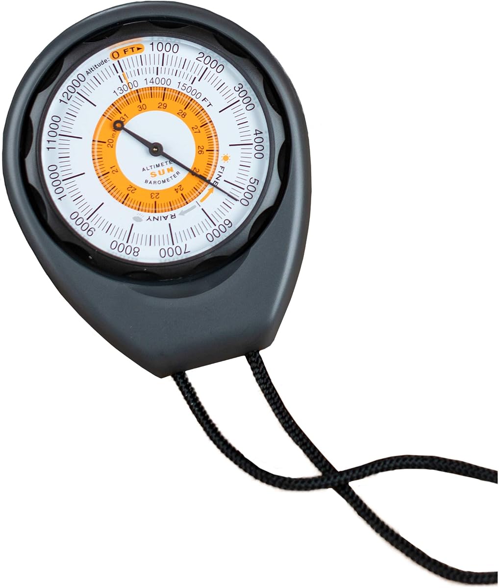
The Sun Company Altimeter 203 stands out as a reliable analog tool for outdoor enthusiasts who prefer simplicity. It boasts a 4.3 rating from users who appreciate its battery-free operation and rugged design for everyday use.
We may earn a commission when you buy through this link, at no additional cost to you.
Its adjustable dial allows you to account for high or low pressure systems ensuring accurate altitude readings. The weather-trend indicator helps you predict incoming weather changes based on barometric pressure shifts in inches of Mercury.
While it requires manual calibration which can be tricky for beginners the reliability of an analog device is unmatched in remote areas without power sources. The included lanyard makes it easy to carry on hikes or keep in your vehicle.
Hikers and campers looking for a no-fuss tool should consider this model for its durability and ease of use. It pairs well with other analog tools like compasses to create a complete analog navigation kit.
This device operates without batteries ensuring it works whenever you need it in the field.
Use the trend indicator to spot pressure changes that often signal upcoming storms.
We may earn a commission when you buy through this link, at no additional cost to you.
The BTMETER BT-100WM is a multifunctional digital device that goes beyond simple altitude tracking to offer comprehensive weather data. It holds a 4.1 rating reflecting its utility for outdoor activities like sailing and drone driving.
We may earn a commission when you buy through this link, at no additional cost to you.
This anemometer measures wind speed temperature humidity and dew point alongside barometric pressure and altitude. You can log 16 groups of barometric pressure data to analyze trends over time which is useful for weather forecasting.
The digital interface offers multiple unit options such as mph km/h and knots for wind speed while the backlit screen ensures readability in low light conditions. However setting up the logging features may require some time to master.
Outdoor enthusiasts who need detailed environmental data will find this device invaluable for planning trips. It is a strong choice for those who want to monitor wind and pressure conditions alongside their elevation changes.
Tracks wind speed humidity and temperature alongside altitude for a full weather picture.
Records pressure data to help you understand local weather patterns and trends.
We may earn a commission when you buy through this link, at no additional cost to you.
This digital compass altimeter offers an impressive array of eight functions including altitude barometer compass and thermometer in a compact handheld tool. It has a 3.4 rating indicating potential variability in quality but remains a popular budget option.
We may earn a commission when you buy through this link, at no additional cost to you.
The altitude measurement range extends from -2300 to 29500ft providing coverage for most high-altitude activities. The digital barometer measures between 300mbar to 1100mbar while the electronic compass provides eight-direction guidance for orientation.
While the build quality is basic compared to premium models the included carrying rope and backlight add convenience for everyday use. It is an accessible entry point for those who want multiple tools without a significant financial investment.
Casual hikers or budget-conscious travelers might find this device sufficient for general tracking needs. It serves as a lightweight addition to a gear pack where cost is a primary consideration for multi-functionality.
Combines eight different measurement tools into one small device for versatility.
Supports elevations up to nearly 30000 feet for mountain climbing.
We may earn a commission when you buy through this link, at no additional cost to you.
This digital altimeter device functions as an eight-in-one instrument providing altitude barometer compass and temperature data for outdoor adventurers. With a 3.9 rating it offers a balanced performance for those seeking a compact multi-tool.
We may earn a commission when you buy through this link, at no additional cost to you.
The altitude range spans from -2300 to 29500 feet which covers most hiking and climbing scenarios effectively. The digital barometer reads from 300 mbar to 1100 mbar and the thermometer supports temperatures from 14°F to 140°F.
The electronic compass features an eight-direction display that adjusts based on magnetic fields to keep you oriented. While it is lightweight and portable the build quality may not withstand extreme abuse compared to ruggedized models.
Casual hikers or travelers who need a simple all-in-one tool might appreciate its versatility. It is a good option for light outdoor use where space and weight are critical factors in your gear choices.
Consolidates multiple essential navigation tools into a single handheld device.
Handles extreme altitudes and temperatures suitable for various environments.
We may earn a commission when you buy through this link, at no additional cost to you.
The Sun Company AltiLINQ is designed specifically for vehicle use with a dashboard mounting system for easy visibility while driving. It shares a 4.2 rating from users who value its analog reliability and easy-to-read scale.
We may earn a commission when you buy through this link, at no additional cost to you.
Like its sibling model it uses a battery-free analog sensor that adjusts based on surrounding barometric pressure for altitude readings. The dashboard mount kit allows you to attach it to the top or front of your dash securely.
This device includes a weather trend indicator to help predict incoming low or high-pressure systems during your trips. While it is optimized for cars it can be detached for use on trails making it versatile for mixed use.
Drivers planning mountain road trips will find this altimeter useful for tracking elevation changes in real time. It is an excellent choice for those who want analog simplicity in their vehicle without relying on electronic systems.
Designed with mounting options that fit easily into your car or truck dashboard.
Operates without batteries ensuring it is ready whenever you drive in the mountains.
We may earn a commission when you buy through this link, at no additional cost to you.
This handheld clinometer serves as a sighting altimeter ideal for measuring height and slope in field work or forestry. It has a 4.5 rating reflecting its solid build and accuracy for professional or serious outdoor applications.
We may earn a commission when you buy through this link, at no additional cost to you.
The aluminum alloy body makes it sturdy waterproof and shockproof so it can withstand rugged field conditions. It features a deflection angle lens that makes quick measurements straightforward and easier to read clearly.
Readings are provided in both inches and millimeters which is useful for various surveying needs. The included thick nylon carry bag ensures the tool is protected when not in use during long trips or transport.
Field workers foresters or hikers interested in precise slope angles will find this tool highly reliable. It is built to last and offers the durability needed for repeated use in challenging environments.
Constructed from waterproof aluminum alloy to handle harsh field conditions.
Uses a deflection angle lens for accurate and quick height measurements.
We may earn a commission when you buy through this link, at no additional cost to you.
The Garmin GPSMAP 65s is a premium handheld GPS device that includes a barometric altimeter and compass for high-precision navigation. With a 4.6 rating it is the top choice for serious outdoor enthusiasts needing reliable data.
We may earn a commission when you buy through this link, at no additional cost to you.
It features a large 2.6-inch color display that is readable in sunlight and supports expanded satellite systems including multi-band technology for challenging locations. The included routable TopoActive map helps you navigate complex terrain with ease.
The device supports the Garmin Explore website and app for managing tracks and routes after your field work. While it is more expensive than basic altimeters the added mapping and connectivity features justify the investment for many users.
Adventure seekers and professionals who require accurate location and elevation data will appreciate this unit. It is a comprehensive tool that combines GPS navigation with a reliable barometric altimeter for safety and performance.
Supports expanded satellite networks for optimal accuracy in canyons or forests.
Includes routable maps and app compatibility for planning and reviewing tracks.
We may earn a commission when you buy through this link, at no additional cost to you.
This compact handheld device combines a precision altimeter barometer and thermometer into one unit with a built-in carabiner. It boasts a 5.0 rating indicating excellent user satisfaction with its convenience and durability.
We may earn a commission when you buy through this link, at no additional cost to you.
The integrated carabiner hook allows you to attach the device to backpack straps or vests for hands-free carrying. It features an advanced barometric pressure sensor that predicts conditions for the upcoming 12 to 24 hours.
Constructed from high strength ABS material it is built to withstand drops and impacts in harsh outdoor environments. Its versatile design also allows it to be used as a dashboard instrument in vehicles for road trips.
Hikers and campers who want a lightweight tool to attach to their gear will find this appealing. It is a practical solution for those who need quick access to elevation and temperature data while on the move.
Features a carabiner hook for easy attachment to backpacks or gear.
Predicts upcoming weather conditions based on barometric pressure changes.
We may earn a commission when you buy through this link, at no additional cost to you.
This mini aluminum altimeter is designed to measure height and slope in a compact form factor suitable for pockets. It has a 3.9 rating reflecting its professional utility for architects travelers and explorers.
We may earn a commission when you buy through this link, at no additional cost to you.
Made of aluminum alloy the device is compressive waterproof and shockproof ensuring durability during use. It features a hand strap to prevent losing the unit while using the deflection angle lens to measure targets.
The high-definition azimuth plate and clear dial allow for quick measurements and easy reading in various conditions. It comes with a soft thick bulletproof fabric box that provides comfortable protection when the tool is not in use.
Professionals and travelers who need a small reliable tool for slope measurement will find this helpful. Its light weight and sturdy construction make it easy to carry anywhere without adding bulk to your gear.
Small enough to fit in a pocket while remaining durable enough for field work.
Includes a soft fabric box with velcro to keep the device safe.
We may earn a commission when you buy through this link, at no additional cost to you.
This multifunctional sports watch combines GPS tracking with altitude and weather data for outdoor fans. It holds a 3.2 rating reflecting varied experiences but offers extensive tracking features at a reasonable price point.
We may earn a commission when you buy through this link, at no additional cost to you.
It uses GPS GLONASS and BeiDou satellite systems for accurate positioning with an error within 1m. The altimeter tracks historical high records and trends while offering height target reminders to help you stay on goal.
The device features a USB rechargeable battery and includes a backlight plus an LED flashlight for emergencies. With six common functions including compass and pedometer it is a feature-packed option for sports and hiking.
Athletes or hikers who want GPS tracking without the cost of a full GPS unit may find this appealing. It is a versatile tool for those who want detailed tracking and reminders for their outdoor activities.
Supports three satellite systems for improved positioning in remote areas.
Includes altitude reminders and trend tracking to monitor your progress.
We may earn a commission when you buy through this link, at no additional cost to you.
Choosing the right handheld altimeter depends on your specific outdoor activities and how much detail you need from your device.
Accuracy is the most critical factor when selecting an altimeter. Digital devices often require calibration against known points to ensure precise readings, while analog models may drift over time due to mechanical wear or pressure changes.
Look for adjustable dials or digital calibration options to maintain precision during long hikes.
Consider whether you prefer analog or digital devices. Analog altimeters are battery-free and reliable in the field but require manual adjustments. Digital models offer more features but need batteries or rechargeable power sources.
If you prioritize simplicity and reliability, choose a battery-free analog device.
Outdoor conditions can be harsh, so the build quality of your altimeter matters. Look for waterproof shockproof materials like aluminum or rugged ABS plastic that can withstand drops and rain.
A sturdy case and protective cover will extend the life of your device.
Many modern altimeters come with extra tools like thermometers compasses and barometers. Decide which extra features you need to avoid paying for unnecessary complexity.
An 8-in-1 device might be useful for some but simpler models offer better reliability for just altitude.
Ensure the display is easy to read in various lighting conditions. Digital models often have backlit screens while analog ones rely on physical dials that should be clearly marked.
A large display helps you check readings quickly without stopping your progress.
Consider how you will carry the device. Some altimeters come with lanyards or carabiners while others are designed for vehicle dashboard mounting.
Choose a mounting style that fits your gear and activity needs.
Prices vary significantly between basic analog models and advanced GPS units. Determine your budget and balance cost with the features you need for your trips.
More expensive does not always mean better if you do not need advanced mapping capabilities.
Some models include barometric pressure trends to predict weather changes. This feature is valuable for campers who need to anticipate storms.
Check if the device tracks pressure trends or just static readings.
Start by calibrating your altimeter to a known elevation point such as a trailhead or summit. For digital devices use the auto or manual calibration feature. For analog models turn the dial to match your current height.
Keep the device away from direct heat sources which can affect the internal sensors or mechanical parts. If your device is waterproof check seals regularly and clean it after exposure to saltwater or dirt.
For analog units store them in a cool dry place to prevent mechanical wear. For digital models ensure the battery or charge is maintained and reset the clock if the unit loses power during storage.
Handheld altimeters based on barometric pressure are generally accurate within a few feet if calibrated. GPS elevation data can be less reliable due to signal limitations especially in canyons. Combining both provides the best reliability.
Most digital altimeters require batteries to power the display and sensors. Some newer models offer USB rechargeable options. Analog altimeters do not need batteries but require manual adjustment instead.
Yes most altimeters can measure from zero or below sea level. Check the specs for the minimum range which often includes negative values. This ensures the device works for dives or valleys as well.
Pressure changes due to weather can affect readings even if your elevation is constant. Recalibrate the device when you reach a known elevation. Ensure the device is not exposed to extreme heat or physical shocks.
Yes many models feature waterproof designs suitable for outdoor use. Look for specific IP ratings or terms like weatherproof. If it is not waterproof keep it in a protective case during rain.
Basic models often cover up to 15000 feet while advanced digital units support over 25000 feet. Choose a range that fits your highest expected activity level like mountain climbing.
Whether you need a simple analog tool or a GPS enabled device there is an altimeter to fit your needs. The Sun Company Altimeter 203 offers reliability while the Garmin GPSMAP 65s provides premium navigation.
Consider your primary use case whether it is hiking fishing or general travel when selecting a model. Prioritize durability and ease of calibration to ensure consistent performance on your adventures.
Remember that prices and availability may change so check the current listings before purchasing. Investing in the right altimeter will help you track your elevation with confidence.